
Making shapes using coordinates
Loading the math board and drawing, please wait…
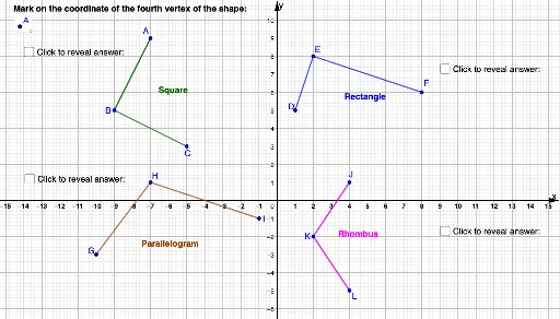
① This example demonstrates how to construct various geometric shapes, such as triangles and quadrilaterals, by inputting coordinate points and using GeoGebra's segment and polygon tools, highlighting the fundamental role of coordinates in shape creation. ② Core mathematical concepts include the Cartesian coordinate system, point coordinates, definitions of segments and polygons, and coordinate-based features of special shapes like equilateral triangles and exponential functions. ③ Construction highlights: Based on the construction summary, the commands Segment and Polygon are used, creating numerous points (A, B, C, D, etc.) that are connected to form closed figures; text objects (text1~text4) label coordinates or explanations, while auxiliary lines (f, g, h, etc.) and parameters (m_1, q1, etc.) may allow dynamic adjustments. ④ Suitable for middle school to high school students learning introductory analytic geometry, and for teachers demonstrating the relationship between coordinates and shapes in class, helping students intuitively understand coordinate positioning and basic geometric construction.
GeoGebra Commands & Parameters
Segment(A, B) → fSegment(C, B) → gSegment(D, E) → hSegment(F, E) → iSegment(G, H) → jSegment(I, H) → kSegment(J, K) → lSegment(L, K) → mPolygon(A, B, C, M) → q1, a, b, c, m_1Polygon(D, E, F, N) → q2, d, e, f_1, nPolygon(G, H, I, O) → q3, g_1, h_1, i_1, oPolygon(J, K, L, P) → q4, j_1, k_1, l_1, p
AI Drawing Prompt Reference
In a Cartesian coordinate plane, draw four separate quadrilaterals. Each quadrilateral has four vertices, with three of them connected by line segments to form two sides, and the fourth vertex connected to one of the others. Then use a polygon tool to enclose all four vertices into a closed shape. The four quadrilaterals are placed in different regions, with varied shapes—some resembling triangles, others trapezoids. Add text labels near the shapes to indicate vertex coordinates or brief explanations. This demonstrates how coordinate points define positions and construct basic geometric figures, suitable for beginners learning the relationship between coordinates and shapes.
The prompt above was compiled from the original drawing commands and is for reference only.