
Locations on a Sphere: Latitude, Longitude, and 3D Coordinates
Loading the math board and drawing, please wait…
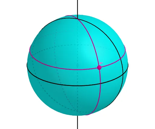
① This example demonstrates how to locate any point on a sphere using latitude and longitude parameters, dynamically generating the point and its projections in 3D space, and visually showing the conversion between spherical and Cartesian coordinates. ② Core mathematical concepts include spherical geometry, the latitude/longitude system, the application of trigonometric functions (sine and cosine) in 3D coordinates, and the properties of intersections between planes and spheres (great/small circles). ③ Construction highlights: using GeoGebra commands such as Sphere to create the sphere, Plane and IntersectPath to construct latitude circles and longitude arcs, Rotate to change latitude/longitude by rotating planes or points, Line and OrthogonalPlane to build auxiliary reference axes and perpendicular planes, with objects O (center), a, c, b, d (axes or auxiliary lines), Latitude, Longitude (angle sliders), P, P', P'' (sphere point and its projections) linked together for an interactive model. ④ Suitable for high school or early college students learning solid geometry, spherical coordinates, and trigonometric applications; also useful for geography or astronomy lessons explaining latitude and longitude, and for teachers creating interactive courseware.
GeoGebra Commands & Parameters
Sphere(O, 1) → aIntersectPath(xOyPlane, a) → cPlane(zAxis, xAxis) → bIntersectPath(b, a) → dRotate(P, (-Latitude), yAxis) → P'Line(O, O + (0, 0, 1)) → fRotate(P', Longitude, zAxis) → P''Plane(P'', f) → eOrthogonalPlane(P'', f) → gIntersectPath(g, a) → hIntersectPath(e, a) → k
AI Drawing Prompt Reference
Draw a unit sphere centered at the origin. On the horizontal plane, show the equator circle, and in a vertical plane, draw a great circle as a reference meridian. Add two sliders for latitude and longitude. Based on the latitude value, rotate a point on the equator around the horizontal axis to get a point on the sphere; then rotate that point around the vertical axis by the longitude value to get the final sphere point. Drop a perpendicular from this point to the horizontal plane to show its projection. Also, construct a plane through this point perpendicular to the vertical axis, intersecting the sphere to form a latitude circle, and a plane through this point containing the vertical axis, intersecting the sphere to form a longitude arc. Display the center, coordinate axes, and these auxiliary circles and arcs, creating an interactive 3D spherical coordinate model.
The prompt above was compiled from the original drawing commands and is for reference only.