
Lesson 7.3 - Geometric Mean (Right Triangle Altitude Theorem)
Loading the math board and drawing, please wait…
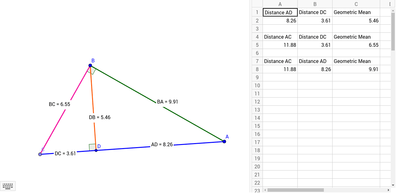
①This example demonstrates the geometric mean relationship in a right triangle: the altitude to the hypotenuse divides the hypotenuse into two segments, and the altitude is the geometric mean of those segments; each leg is also the geometric mean of the hypotenuse and the adjacent segment.②Core mathematical concepts include geometric mean, similar triangles, mean proportional, and the right triangle altitude theorem (Euclidean theorem).③Construction highlights: using GeoGebra commands such as Segment, OrthogonalLine, Point, Intersect, Angle, and Distance, a right triangle ABC is constructed with altitude AD to the hypotenuse, and segment lengths (distanceAD, distanceDC, distanceDB, distanceBA, distanceBC) are measured and displayed via text objects (TextAD, etc.) to verify the geometric mean relations.④Suitable for upper middle school or high school geometry classes, this interactive tool helps students intuitively grasp the geometric mean and the right triangle altitude theorem, and can be used for exploratory learning.
GeoGebra Commands & Parameters
Segment(B, A) → aOrthogonalLine(B, a) → bPoint(b) → CSegment(A, C) → cSegment(C, B) → dOrthogonalLine(B, c) → eIntersect(e, c) → DSegment(D, B) → fAngle(C, B, A) → αAngle(B, D, C) → βDistance(A, D) → distanceADDistance(D, C) → distanceDCDistance(D, B) → distanceDBDistance(B, A) → distanceBADistance(B, C) → distanceBCDistance(A, D) → ADDistance(D, C) → DCDistance(A, C) → AC
AI Drawing Prompt Reference
Draw a right triangle with one leg horizontal and the hypotenuse sloping upward from the right endpoint of that leg. From the right-angle vertex, draw an altitude perpendicular to the hypotenuse, meeting it at a point. Mark the right angle symbol. Display the lengths of the two segments on the hypotenuse created by the altitude, the length of the altitude itself, the length of the hypotenuse, and the length of one leg. Label these lengths with text to show that the altitude is the geometric mean of the two hypotenuse segments, and each leg is the geometric mean of the hypotenuse and the adjacent segment.
The prompt above was compiled from the original drawing commands and is for reference only.