
Dynamic Construction and Properties of the Orthocenter of a Triangle
Loading the math board and drawing, please wait…
In collections
Points of Concurrency
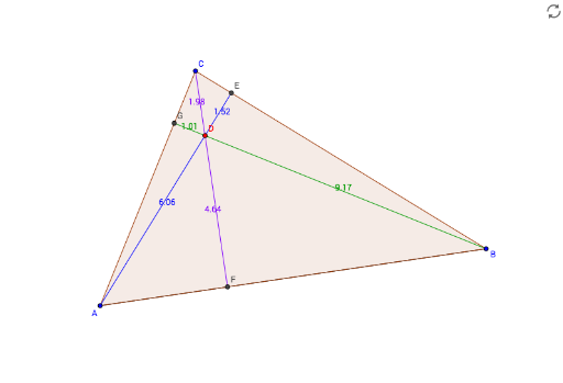
① This GeoGebra example dynamically demonstrates the geometric phenomenon that the three altitudes of a triangle intersect at a single point (the orthocenter), and shows how the orthocenter moves as the triangle's vertices change. ② The core mathematical concept is the orthocenter of a triangle, the intersection of its three altitudes, involving perpendicular relationships, segment and polygon construction, and the geometric meaning of intersections. ③ Construction highlights: from the construction summary, it uses Segment to create triangle sides, Polygon to form the triangle, OrthogonalLine to draw altitudes from vertices to opposite sides, and Intersect to find the intersection points, ultimately obtaining the orthocenter (points D, E, F, etc.), possibly with auxiliary lines (a_1, b, c, etc.) to complete the figure. ④ Suitable for middle school to high school students learning about the five centers of a triangle (centroid, orthocenter, circumcenter, incenter, excenter), and for dynamic exploration in geometry teaching to understand orthocenter properties and the concurrency of altitudes.
GeoGebra Commands & Parameters
Segment(A, B) → aPolygon(A, B, C) → poly1, c, a_1, bOrthogonalLine(C, a) → dOrthogonalLine(A, a_1) → eOrthogonalLine(B, b) → fIntersect(f, d) → DSegment(A, D) → gIntersect(e, a_1) → ESegment(D, E) → hSegment(C, D) → iIntersect(d, a) → FSegment(D, F) → jSegment(B, D) → kIntersect(f, b) → GSegment(D, G) → l
AI Drawing Prompt Reference
Draw a triangle and dynamically show how its three altitudes intersect at a single point (orthocenter), moving as the triangle's vertices change. Start by constructing the triangle's sides, then draw perpendicular lines from each vertex to the opposite side to find the feet of the altitudes, and finally connect these feet to highlight the orthocenter.
The prompt above was compiled from the original drawing commands and is for reference only.