
Areas with Geoboard
Loading the math board and drawing, please wait…
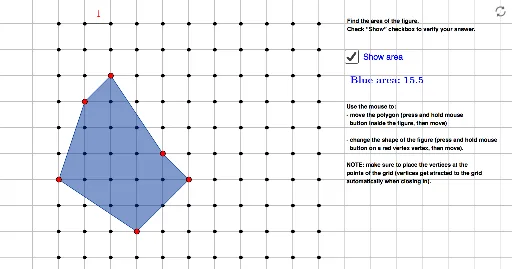
Interactive exercise demonstrating how to calculate areas using geoboards. This example illustrates the calculation of areas by drawing various shapes on a geoboard. Key math concepts involved include area, trigonometric functions, line segments, integers, combinatorics, and reflection. GeoGebra commands used in construction are Sequence, Point, Polygon, and Segment. Suitable for middle school and above, this exercise helps students understand and practice area calculations in geometry.
GeoGebra Commands & Parameters
Sequence(Sequence[(i, j), j, 1, m], i, 1, n) → myGeoPoint(myGeo) → M1Polygon(I, J, K, L, M, M1) → BlueShape, i, j, k, l, t, f_1Point(myGeo) → APoint(myGeo) → BSegment(A, B) → a
AI Drawing Prompt Reference
Draw multiple shapes on a grid to demonstrate how to calculate areas using various figures. Each shape is formed by connecting points located at the intersections of the grid. First, create a sequence to determine the vertex positions for each polygon, then draw the polygons using these vertices. Additionally, select two arbitrary points on the grid and connect them with a line segment. Together, these shapes and segments create a geometric teaching demonstration that aids in understanding area calculations.
The prompt above was compiled from the original drawing commands and is for reference only.