
Polar and Rectangular Coordinates
Loading the math board and drawing, please wait…
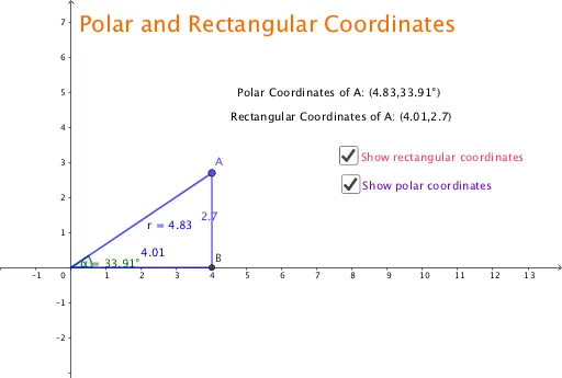
This example demonstrates the conversion between polar and rectangular coordinates. Key mathematical concepts include coordinate system conversion, and the representation of angles and distances. Using GeoGebra commands such as OrthogonalLine and Intersect, the process of coordinate conversion can be visually understood. Suitable for high school mathematics education and learning.
GeoGebra Commands & Parameters
OrthogonalLine(A, xAxis) → fIntersect(f, xAxis) → BSegment(A, B) → bIntersect(xAxis, yAxis) → CSegment(B, C) → cPoint(xAxis) → DAngle(D, C, A) → αSegment(C, A) → r
AI Drawing Prompt Reference
Draw a Cartesian coordinate system with x and y axes. Mark the intersection point of the axes. Take a point on the x-axis and connect it to the origin, forming a line segment. Represent the angle between the line segment and the x-axis in radians. Draw a perpendicular line from the point on the x-axis to the y-axis, marking the foot of the perpendicular. Connect the foot of the perpendicular to the point on the x-axis with a dashed line to show the relationship between polar and rectangular coordinates.
The prompt above was compiled from the original drawing commands and is for reference only.