
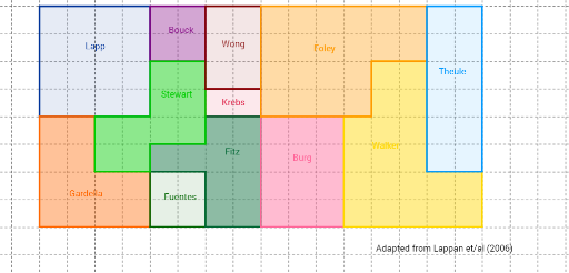
What fraction of the land does each farmer own?
Loading the math board and drawing, please wait…
This example demonstrates how to use GeoGebra to draw polygons and calculate the fraction of land owned by each farmer. Core math concepts include fractions, polygon area calculation, and geometric construction. Key GeoGebra commands used are Point and Polygon, with objects like A, B, C, D, pic1, and potentially E, F, G, H, Lapp. Suitable for middle school students and above to learn fractions, area calculation, geometric construction, and probability statistics.
GeoGebra Commands & Parameters
Point(Circle[A, 8]) → BPoint(Circle[E, 4]) → FPolygon(E, F, G, H) → Lapp, e, f, g, hPoint(Circle[I, 4]) → JPolygon(I, J, K, L, M, N) → Gardella, i, j, k, l, m, nPoint(Circle[O, 2]) → PPolygon(O, P, Q, R) → Fuentes, o, p, q, rPoint(Circle[S, 2]) → TPolygon(S, T, U, V) → Bouck, s, t, u, vPoint(Circle[G_1, 1]) → H_1Polygon(G_1, H_1, I_1, J_1) → Krebs, g_1, h_1, i_1, j_1Point(Circle[K_1, 1]) → L_1Polygon(K_1, L_1, M_1, N_1, O_1, P_1, Q_1, R_1) → Fitz, k_1, l_1, m_1, n_1, o_1, p_1, q_1, r_1Point(Circle[S_1, 2]) → T_1Polygon(S_1, T_1, U_1, V_1, W_1, Z_1, A_2, B_2) → Stewart, s_1, t_1, u_1, v_1, w_1, z_1, a_2, b_2Point(Circle[C_2, 2]) → D_2Polygon(C_2, D_2, E_2, F_2) → Wong, c_2, d_2, e_2, f_2Point(Circle[W, 3]) → ZPolygon(W, Z, A_1, B_1) → Burg, w, z, a_1, b_1Point(Circle[K_2, 4]) → C_1Polygon(K_2, C_1, D_1, E_1, F_1, G_2, I_2, J_2) → Walker, k_2, c_1, d_1, e_1, f_1, g_2, i_2, j_2Point(Circle[L_2, 4]) → M_2Polygon(L_2, M_2, N_2, O_2, P_2, Q_2) → Foley, l_2, m_2, n_2, o_2, p_2, q_2Point(Circle[R_2, 2]) → S_2Polygon(R_2, S_2, T_2, U_2) → Theule, r_2, s_2, t_2, u_2Point(Circle[A_3, 8]) → V_2
AI Drawing Prompt Reference
Draw multiple polygonal land areas for different farmers, with each area defined by specific points, such as Farmer A's land by points C, E, I, O, S, W, K, L, R, S, T, U, V, G, H, I, J, K, L, M, N, O, P, Q, R. Sequentially draw the boundaries of each farmer's land, calculate the area of each region, and determine the proportion of land owned by each farmer.
The prompt above was compiled from the original drawing commands and is for reference only.