
Dilation on Coordinate Grid 1
Loading the math board and drawing, please wait…
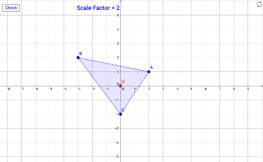
① This example demonstrates the dilation (scaling) of a polygon on a coordinate grid, showing the original triangle and its scaled image side by side. ② The core mathematical concept is the dilation transformation in plane geometry, involving a scale factor, a center of dilation, and the property that corresponding points lie on lines through the center while the shape remains similar but changes size. ③ Construction details: The original triangle is built using the Polygon command, and the dilated triangle is generated with the Dilate command; a slider (scaleFactor) controls the scaling ratio, and a button (button1) with text objects (correctText/wrongText) provides interactive feedback for checking the user's understanding. Key objects include points A, B, C and their images A', B', C', as well as polygons poly1 and targetPoly. ④ Suitable for middle school or early high school students learning similarity transformations, and useful for classroom demonstrations or self-paced practice in geometric construction and dynamic exploration.
GeoGebra Commands & Parameters
Polygon(A, B, C) → poly1, c, a, bDilate(A, scaleFactor, D) → A'Dilate(B, scaleFactor, D) → B'Dilate(C, scaleFactor, D) → C'Polygon(A', B', C') → targetPoly, c', a', b'
AI Drawing Prompt Reference
Draw a triangle ABC, then dilate it with point D as the center and the scaleFactor slider value to get triangle A'B'C'. Place the two triangles side by side for comparison.
The prompt above was compiled from the original drawing commands and is for reference only.